Hiking Grövelsjön – Hiking trails in Grövelsjön
Are you going hiking in Grövelsjön?
We have collected some of the most frequent and best hiking trails in Grövelsjön. In the article you will find good and easy hikes that you can do when you are in this beautiful mountain environment. Grövelsjön is truly magically beautiful and you can get energy and have magical experiences here! Come and hike Grövelsjön! Hike in Dalarna! At the bottom of the article you will find accommodation and shops in Grövelsjön and the surrounding area!
Grövelsjön hiking trails
1. Hävlingen
2. the top of Storvätteshågna
3. Långfjället around
4. Silverfallet
5. The nature trail
6. Jakobshöjden
7. Valdalsbygget
8. Southern King’s Trail
Hiking trails in Grövelsjön
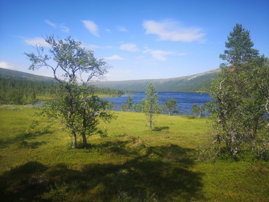
Grövelsjön offers magnificent nature, where you can easily be amazed by all the views of the mountain range. Here the mountains are easily accessible for both young and old, where the hiking tours vary from short to long tours. Grövelsjön is located at a very close distance to both the Swedish and Norwegian mountains, where a hiking trip does not have to be long before enjoying the powerful views of the mountain ranges. There are both easy hiking trails and slightly tougher hiking trails.
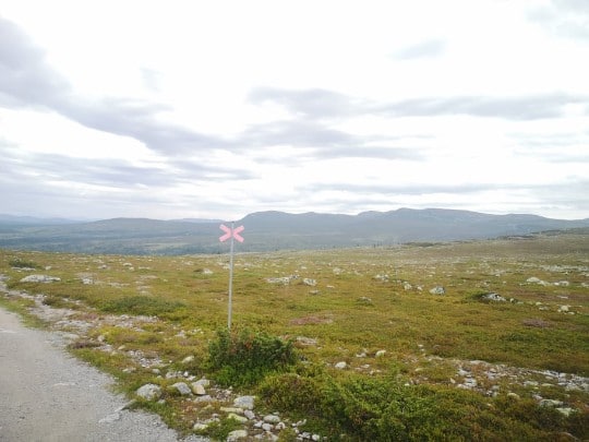
Photo: Marianne Johansson
Grövelsjön hike
The area around Grövelsjön extends far and wide, where the hiking trails are many, with several trails that are well trampled and marked. So experience a hiking trip over Grövelsjön’s mountain plain or a more challenging summit climb on one of all these mountain peaks that Grövelsjön has to offer. Below are 5 nice and mixed hikes that you can do in Grövelsjön.
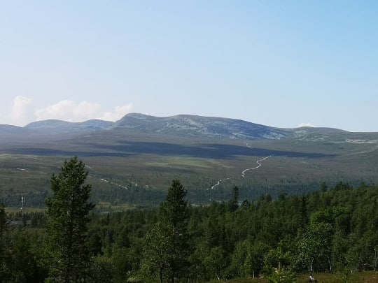
Storvätteshågna, about 20 km round trip Hiking
At 1204 metres above sea level you will find the top of Storvätteshågna, Svealand’s and Dalarna’s highest mountain, which is located in the northern part of Långfjället. On well-trodden paths you generally walk an easy hike across open mountain ranges, where the climb and its length are more demanding than its surface.
You can start your hike from three different places:
- Via Grövelsjöns Fjällstation, about 20 km round trip.
- Via Sommarparkeringen, about 18 km round trip, which is found by turning right just before Grövelsjöns Fjällstation onto a small narrow gravel road about 1 km.
- Via Lövåsen, about 21 km round trip.
Fill up on water at the hiking trail
You follow the hiking trail that goes towards Storvätteshågna and Fosksjöarna. Once at Fosksjöarna there are opportunities to fill up with water, which you can also do, halfway along the trail to Fosksjöarna. At Fosksjöarna you cross the bridge towards Storvätteshågna and walk along the summer trail up to the top. Once up to the top from Fosksjöarna, the climb is relatively heavy.
Just before the top you will find a small pond, and once up on Storvätteshågna, magnificent views spread out, and you can see mountain ranges from Norway, Jämtland and Dalarna. To make the most of all the views of the mountain world, it is recommended to bring a tent and pitch it at Fosksjöarna.
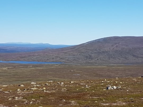
Photo: Marianne Johansson
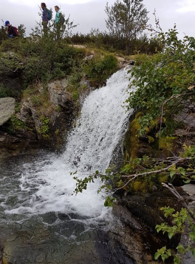
Silverfallet and Olåns Vindskydd, about 6 km round trip Hiking
An easy hike, excellent for both young and old. The hiking trail goes on well-trodden paths and footpaths, through mountain forest and bare mountain, with open beautiful views of Dalarna’s highest mountain Storvätteshågna, and the Norwegian mountains in the west.
The fall is located in the Olån valley, right next to the Norwegian border, 3 km southwest of Grövelsjön and 4 km northwest of Storsätern. Once at the falls, you can enjoy your packed lunch or take a dip in the refreshing mountain water and its 3 metre drop.
Barbecue area and slaughterhouse
1 km from the waterfall is Olåns Vindskydd, with the possibility of a barbecue area and a shelter from the wind. Here nature is surrounded by mountain forest and rippling small streams. Start the hike at the car park at Sjöstugan (located below Grövelsjöns Fjällstation). Take the trail to the left, over a suspension bridge that crosses the river Grövlan.
Silverfallet Grövelsjön
Walk along the cross-marked trail, i.e. the winter trail, and follow the sign to Silverfallet. Once at Olåns Vindskydd, the cross-marking stops. Follow the water past the shelter and after a while you will hear the roaring sound of the waterfall. On the way back, you can either go the same way you came from or you go along the reindeer fence northwards, on the Swedish side, and after a short distance turn off towards Grövelsjön. There is also a well-trodden path there.
The hike can also be done from Storsätern (Ollarsliden) and from the Valdalsbygget car park, although the hike will be slightly longer.
Picture: Marianne Johansson
Långfjället round, about 30 km round trip Hiking
A relatively long hiking tour that requires two to three days of hiking, in stages. From a pleasant mountain world to a more indomitable wilderness. The route goes through Rogen and Långfjället Nature Reserve, plus Töfsingdalen National Park. Långfjället provides adventure for a variety of interests, such as
hiking, fishing, skiing and more.
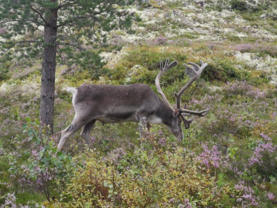
A lot of reindeer graze on Långfjället’s nature reserve, so you should keep in mind to show consideration. It is illegal to disturb the reindeer in accordance with the Reindeer Husbandry Act. The hiking tour goes through Sylen and Hävlingen and along the border between Sweden and Norway.
Short tour and overnight stays
If you choose the short hike (about 24 km), take the boat M/S Sylöra from Sjöstugan across Grövelsjön towards Sylen and start the hike from there. However, if you choose the longer tour (about 30 km), you start your hike from Sjöstugan. The tour goes over Salsfjället on the trail towards Sylen, among varied nature such as bare rock, marshland and mountain ranges.
Spend the night at Sylen
Once at Sylen, there is accommodation to rent. The tour then continues over Långfjället, on the trail towards Hävlingen. Hävlingen is a lake that is located in the middle of nowhere, in the wilderness of the mountains. It is possible to book overnight accommodation in the cabins, from the cabin hosts who are there during the spring and summer. There is also an 8-bed cabin, which is open all year round. Take the trail towards Grövelsjön or discover your own way back. A mountain map of the area and a compass are highly recommended.
Picture: Marianne Johansson
Hävlingen, about 26 km round trip Hiking
Lake Hävlingen is located in the middle of the mountains. The place is notorious for its fishing and is especially popular in sport fishing, where fishing for char is widely known. It is possible to rent accommodation in the Hävlingen cabins, via the County Administrative Board, but only during spring and summer when the cabin host is present.
Hiking cabin – Overnight stay
There is also an 8-bed hiking cabin that is open all year round. It is also possible to hire boats and canoes. Start the hike at Grövelsjöns Fjällstation, and follow Södra kungsleden towards Hävlingen with an approximate distance of 13 km. You can also start from the summer car park, which is found by turning right just before Grövelsjöns Fjällstation, onto a small narrow gravel road about 1 km.
From there you follow the trail towards Hävlingen. The hiking tour moves through varied nature such as mountain plains and marshland. The tour is stretched out over many kilometres but is not particularly steep.
Picture: Marianne Johansson
Southern King’s Trail Hiking
The hiking tour starts at Högfjällshotellet in Sälen, and then follows the trail northwards towards Grövelsjön and the varied mountainous nature through Dalarna. At Grövelsjön, you hike across the Long Mountain Nature Reserve on the southern Kungsleden to Hävlingen, and then go past the county border east of Slugufjället and up towards Storlien, where the hike ends after 34 kilometres.
The hiking trail from Sälen to Grövelsjön is 165 kilometres long. In places the trail is well trodden and visible, while other parts of the trail are barely visible.
Hiking trails Grövelsjön
As you can see, there is every chance to find good and experience-packed hikes when you are in Grövelsjön. These were 5 of the best hikes, subjectively judged of course, there are many more nice places and hiking trails in the area around Grövelsjön. We will fill this article with more hikes in the near future. Grövelsjön is definitely worth your visit!
Accommodation in Grövelsjön
Here you will find mountain stations, hotels, cabins and other accommodation in and around Grövelsjön.
Hällsjönsstugan, Foskros
Björnliden
STF Storrödtjärnstugan
Grövelsjögården
Lövåsgårdens Fjällhotell
Småbruket Västerbäcken
Scoutgården Grövelsjön
Ollarsliden, Grövelsjön
Grövelsjön, STF Mountain Station
Storsätern, Grövelsjön
Hävlingestugorna
Särsjöstugorna, Långfjället
Våndsjöstugorna
Grövelfjäll
Storsätra Mountain Hotel
Camping in several locations
Food and drink
Sjöstugan
Grövelsjön Mountain Bakery
Grövelsjön Alpaca
Femund Fjellstue, Norway
Grövelfjäll/Werners Värdshus, Norway
Lövåsgårdens Fjällhotell
STF Grövelsjön Mountain Station
Renbiten
Storsätra Mountain Hotel
The shops
Fjällbua
Grövelsjön Mountain Bakery
Grövelfjäll
Grövelsjögården
Grövelsjön Alpacka
Grövelsjön Booking
STF Grövelsjön Mountain Station
Renbiten
Many people find here via searches on Google.se
Grövelsjön map hiking trails
Grövelsjön trails
Grövelsjön Dalarna
Mountain hiking Grövelsjön
Hiking Grövelsjön Dalarna
Real mountain environment in Grövelsjön Dalarna
It is magical here and you get experiences here that you really carry with you for a long time! Dalarna has everything and Grövelsjön is the southernmost place where you can experience such a wonderful and unique mountain environment. Many say that Dalarna has everything and we can only agree! Welcome to beautiful Grövelsjön!